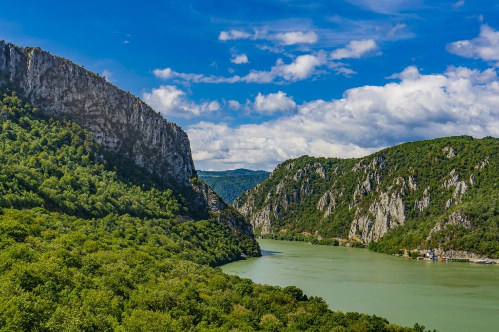
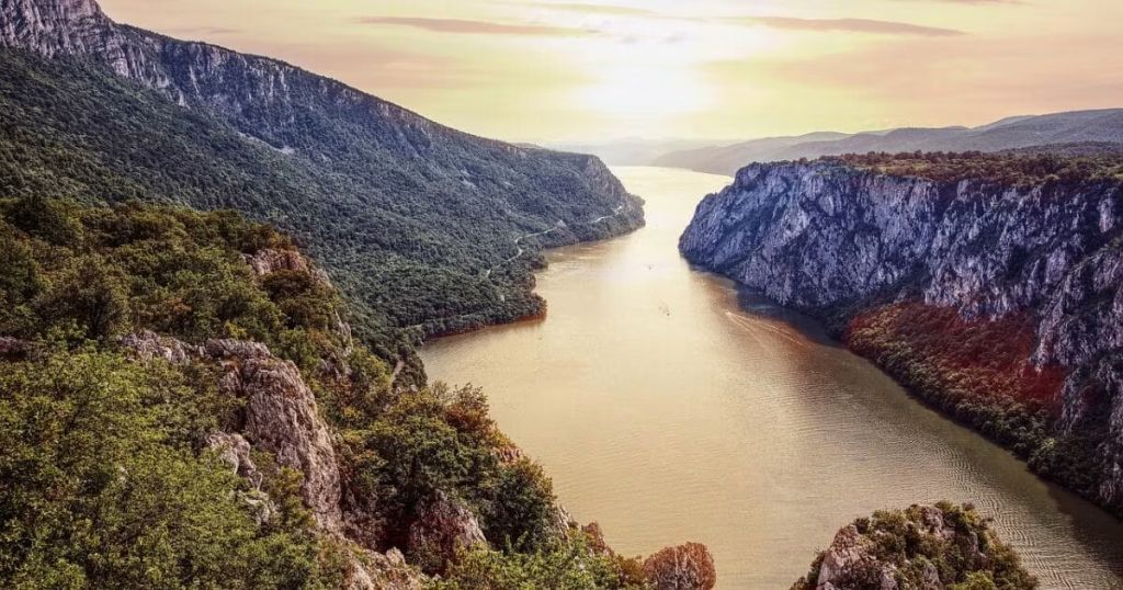
Iron Gates Gorge, eastern Serbia
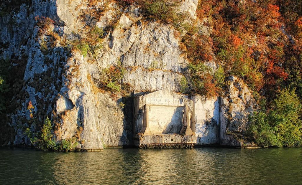
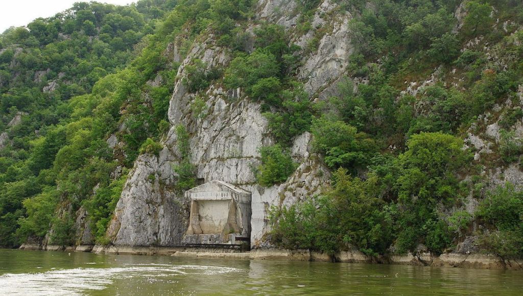
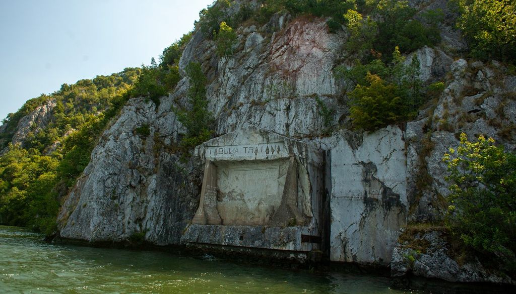
Roman Tabula Traiana, also called Trajan’s Plaque, is an ancient Latin inscription carved into the cliff above the Danube in the Iron Gates section of eastern Serbia. It commemorates Emperor Trajan’s road through the gorge during the period of the Dacian campaigns. Travelers usually treat it as a viewing stop rather than a walk-up monument: the key question is not opening time but how to position yourself for a clear view, usually by boat or from wider Đerdap viewpoints.
Roman Tabula Traiana is a memorial inscription carved into the rock face of the Iron Gates gorge above the Danube. It dates to the reign of Emperor Trajan in the early 2nd century AD and is most closely associated with the Roman road built along the cliffs during the campaigns toward Dacia. What gives it its distinct character is its physical setting: it is not a museum piece moved indoors, but a monument still tied to the river corridor it was made to commemorate. The atmosphere around it is quiet, exposed, and shaped by water, stone, and distance.
For travelers building a broader route, it fits naturally with the wider Eastern Serbia Guide once you understand that the monument is seen within a landscape rather than visited like a city-center landmark.
The Roman Tabula Traiana is important because it records a real engineering problem and a political objective at the same time. The Iron Gates was a difficult section of the Danube frontier: steep rock, a narrow river corridor, and limited room for overland movement. Trajan’s administration pushed a road through this landscape to support military logistics during the Dacian campaigns. The plaque served as a commemoration of that achievement and as a public statement of imperial control.
In practical travel terms, this is what sets Tabula Traiana apart from other Roman sites. You are looking at a monument that still makes sense only when read together with the gorge itself, the Danube route, and the broader cultural landscape now associated with Đerdap National Park. Visitors interested in archaeology often combine it with Lepenski Vir, where the story shifts from imperial Rome to much earlier Danube settlement.
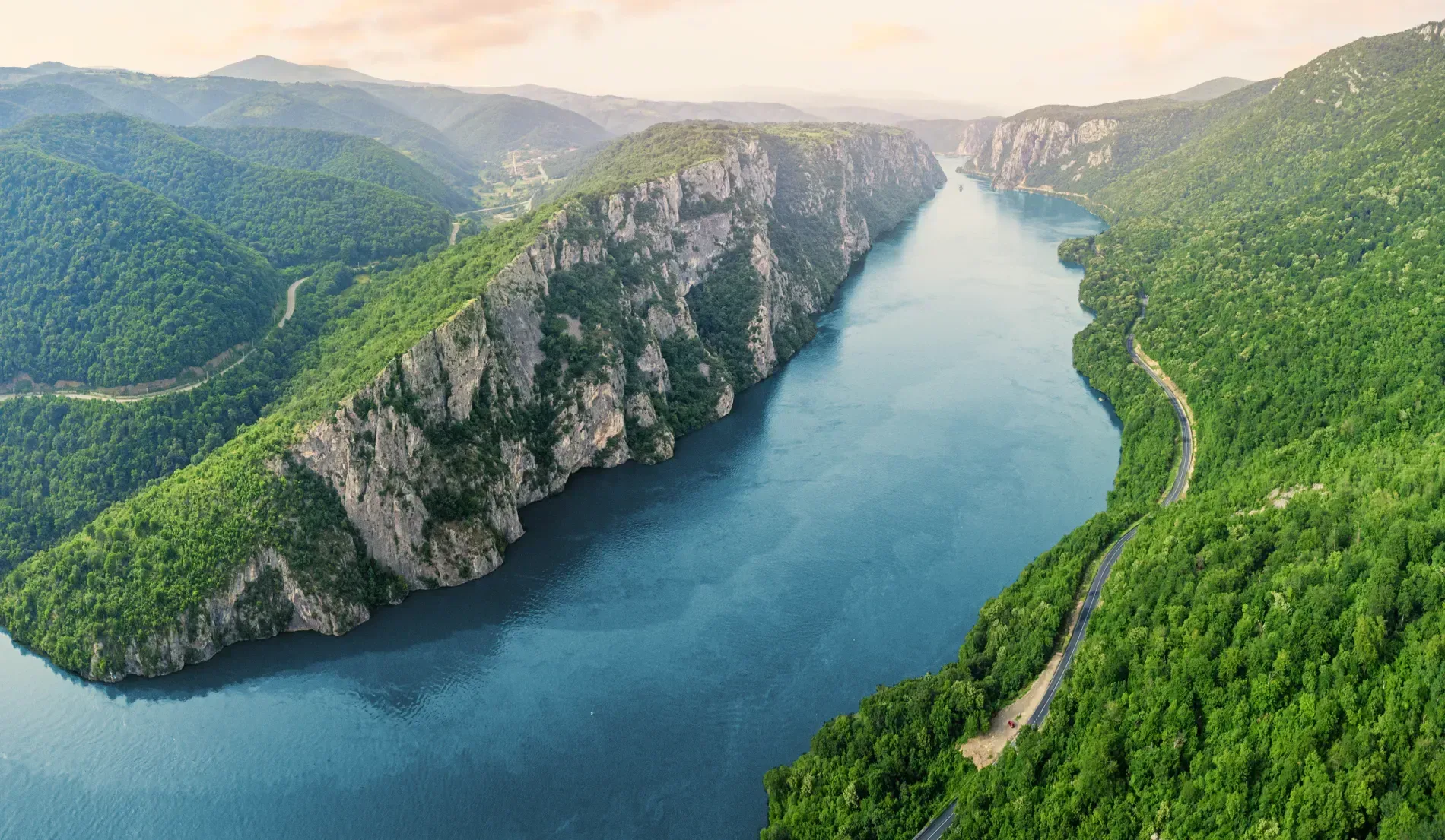
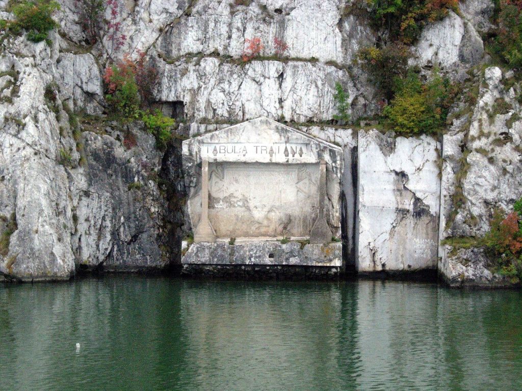
The monument sits within the Iron Gates gorge on the Serbian side of the Danube, in the wider Đerdap area and within reach of Kladovo for road-based travelers. In geographic terms, it belongs to the Danube frontier landscape close to the Serbian-Romanian border zone. That matters because visibility depends on angle, distance, and river position more than on a simple street address.
If you are planning an eastern Serbia loop, think of Tabula Traiana as one stop within a Danube corridor that can also include Golubac Fortress farther upstream. The monument is best understood as part of the river journey through the gorge rather than as an isolated detour.
Spring, summer, and early autumn are the easiest seasons for combining the monument with wider Đerdap travel, especially if your plan depends on river visibility and boat movement. In any season, a clear-weather day matters more than crowd levels because the experience is mostly about seeing the inscription well. Build flexibility into your route if haze, rain, or wind reduce visibility.
For many travelers, the best strategy is to pair the monument with a day of Danube driving, viewpoints, and another confirmed cultural stop. If you are planning transport across the country before reaching the region, the general tools in Serbia Transit Search can help with the larger route even though local viewing logistics still need local confirmation.
The practical way to see the plaque is by arranging your day around the Danube gorge rather than expecting direct urban-style access. Boat-based viewing is the classic approach because it gives the clearest angle on the inscription and its cliff setting. Road travelers should check current local conditions, stopping rules, and viewpoint options before departure.
Because the supplied source set does not confirm boat operators, departure points, or timetables, Serbian Travel recommends confirming those details locally in Kladovo or through your accommodation before setting out.
Expect a short, visual, history-focused stop. There is no evidence in the source set for ticketing, formal visitor services, or fixed hours at the monument itself. Families with older children interested in history usually get more from the stop than travelers expecting an interactive site. Bring layers, sun protection, water, and patience for distance viewing.
Map orientation for the Danube gorge setting of Trajan’s Plaque in eastern Serbia.
These places help turn a short visual stop into a fuller eastern Serbia route focused on the Danube, archaeology, and frontier history.
Roman Tabula Traiana
The cliff inscription itself, best understood as part of the Danube gorge landscape.
A Roman memorial plaque linked to Trajan’s road and the Dacian campaigns. The main experience is viewing and interpreting it in context rather than spending long on site.
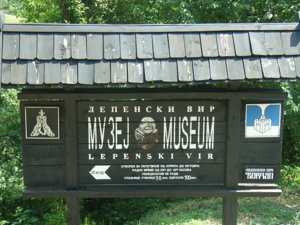
Lepenski Vir
Key prehistoric Danube site that pairs well with the Roman frontier story.
Often combined with the gorge drive for travelers interested in archaeology and long-span human settlement along the Danube.
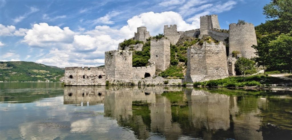
Golubac Fortress
A Danube stronghold at the entrance to the gorge and a logical stop before or after Đerdap driving routes.
Useful for travelers who want a fuller frontier-history day with medieval and landscape context before continuing deeper into the Iron Gates.
Đerdap National Park
The wider protected landscape that gives the plaque its natural setting.
The park context explains why access, viewpoints, and river conditions matter so much when planning a visit to Tabula Traiana.
Iron Gates Gorge, eastern Serbia
Emperor Trajan
Early 2nd century AD
Commemorates Roman road construction through the gorge
Primarily viewed from the Danube or wider gorge viewpoints
Eastern Serbia / Đerdap area
Kladovo area for road travelers
Đerdap National Park, Lepenski Vir, Golubac Fortress
Latin
The plaque is famous for its historical meaning, not for on-site facilities. Bring water, sun protection, and a zoom lens or binoculars if you want to read the carving from a distance. Treat the visit as part of a wider Đerdap day rather than a stand-alone stop.
Tabula Traiana is one of the clearest surviving Roman markers of the empire’s presence on the Danube frontier. It connects military history, engineering, river geography, and the Roman push toward Dacia in one object.
Usually no in the normal sightseeing sense. The practical approach is to plan for a boat-based view or a distant visual stop from the gorge corridor, depending on water conditions and your route that day.
A zoom lens helps more than a wide lens. From a boat, stabilize for motion and spray; from land, look for clear atmospheric conditions rather than rushing for midday light. Drone use may be restricted in protected or border-sensitive areas, so do not assume it is permitted.
It dates to the early 2nd century AD, making it close to 2,000 years old.
It is a Latin commemorative inscription associated with Emperor Trajan and the construction of the Roman road through the gorge.
It links Roman military history, frontier infrastructure, and the Danube landscape in one surviving monument.
Yes. Many travelers pair it with the wider Đerdap area and, depending on route length, sites such as Lepenski Vir or Golubac Fortress.
Yes, it is part of the wider Iron Gates / Đerdap protected gorge environment, which shapes access and viewing conditions.
Stay connected in Serbia